Showing posts with label Door County Geology. Show all posts

Tuesday, April 18, 2023

Niagra Falls

The dolostone rock formation the constitutes the peninsula is known as the Niagara Escarpment. Colloquially called the “ledge”. 

It extends in a great arc from the Fox Cities to the Canadian border in New York - home to Niagara Falls. 

There’s a chunk of the ledge around the corner from where I live that I only learned today features an ephemeral water falls. Thirty years and I was unaware of this hidden secret. 

Southern Door has its own Niagara Falls. 

Hat Tip to the poll workers at the Town Hall for educating me….


Wednesday, December 14, 2022

Door County Basics

I've been collecting these odds and ends about the peninsula for some time and it's about time I shared them with my readers. 

Conventional wisdom suggests that the permanent, year-round population of Door County is only about 26,000 individuals.  According to the last census (2020) the figure is 30,000.  Either way, the total for the entire county is significantly smaller than the population of 48,000 individuals that live in my former hometown of Wauwatosa.  We're small, basically rural with the major population center and industrial hub being Sturgeon Bay.

Door is a curious name for a county dontcha think?    The peninsula takes its name from the treacherous passage and dangerous shoals found between the tip of the peninsula and Washington Island.  The passage is littered with shipwrecks and thusly the early French explorers dubbed it:  Porte des Morts.  Which literally translates to death's door or door of the dead.  The completion of a ship canal in 1881 connecting Sturgeon Bay with Lake Michigan allowing shipping access to and from the bay of Green Bay and Lake Michigan eliminated the longer, time-consuming and dangerous passage around the tip of the peninsula.

Door County consists of 2,370 square miles of which 482 is Terra Firma and 1,888 (80%) being water.  There are 298 miles of coastline.  Only the islands that make up Hawaii have more coastline.  Door county's coastline is home to 11 lighthouses.  Only Long Island's Suffolk County has more lighthouses.  Speaking of shoreline, with the construction of the ship canal (see above) everything north of Sturgeon Bay is technically an island.  Albeit and artificial island but cut-off from the mainland nonetheless.  

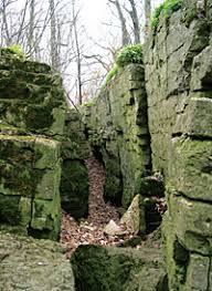
The existence of the peninsula is a consequence of the Niagara Escarpment - a very tenacious formation of dolomite limestone that extends all the way from Buffalo, New York through the Fox Valley.  Multiple glaciations were unsuccessful in scouring it from the face of the earth. 

About 10,000 years ago when the last ice age visited Wisconsin my part of the world was buried beneath an ice sheet almost a mile thick. The earth's crust is still rebounding from the weight of all of that ice.  


Looking at this map you can see how the escarpment transects the peninsula. Visualize the Lake Michigan lobe of the glacier extending south just to the right of the line and the Green Bay lobe of the glacier extending south immediately to the left of the line.  This saucer-shaped geological feature formed from the basin of an ancient inland sea during the Ordovician and Silurian eras some 445 to 420 million years ago.  

Over a period of eons layers of limestone, sandstone and shale were laid down.  The western edge of the escarpment in Wisconsin curves in a semi-circular ridge northeast from Horicon Marsh, toward the eastern edge of Lake Winnebago and the western shore of Door County.  It arcs around Lake Huron, then south through Ontario and ends at Niagara Falls, spanning a total of 650 miles. Some of its edge is underwater or covered by glacial deposits, but much is exposed as cliff outcroppings as high as 200 feet in places.  Geologically-speaking these are old rocks. 


They also happen to be home to some exceedingly-old trees.  Because growing on these cliffs are some of the slowest-growing trees on the planet.  Door County is home to an ancient, old-growth forest.  

Photo - Wisconsin DNR


Three years ago some guys used an incremental borer to extract cores from four of the white cedar trees growing along the edge of the Niagara Escarpment at The Clearing in Ellison Bay. Carefully counting tree rings using a hand lens they discovered that the oldest tree had 397 growth rings.  These slow-growing trees can be more than 300 years of age and have a trunk diameter the size of a 50-cent coin.  The world's oldest red cedar is located on the bluff north of Greenleaf in Brown County.  It is approximately 1,290 years-old and happens to be the only known tree more than 1,000 years of age in Wisconsin.   A 507-year-old white cedar is located on Sven's Bluff at Peninsula State Park and another ancient specimen that is 616 years of age can be found at Fish Creek south of the park. 

It is noteworthy that the peninsula happens to be home to this old stuff.  It sort of makes our short human lifetime here on this earth seem all the more inconsequential and small.  

The Green Bay shoreline is characterized by pebble beaches and the cliffs of the escarpment - sometimes call The Ledge.  Moving east the landmass slopes gently to sea level on the Lake Michigan shoreline which is blessed with sand beaches.  Cursed by shallow soils, for most of the county the depth to bedrock is less than five feet.  17% of the landmass has less than 18 to 36 inches of soil with 22% less than 18 inches.  If you live on the escarpment or the northern two-thirds of the peninsula you build your house atop the dolostone bedrock.

Evidence of the most recent glaciation survives.  Eskers can be found in the southwest corner of the county and drumlins and moraines further up the peninsula.  

The highest point in the county can be seen from my house - Brussels Hill towers a mighty 102 feet above the surrounding countryside.

Door County is also home to the state's tallest sand dune.  Located at Whitefish Bay State Park, Old Baldy is 93 feet above the lake level.

That should give you a decent start on the lay of the land around these parts.  Economics, people,  culture and more to follow.

Stay-tuned as I'll be dribbling-out  more Door County factoids from time-to-time..... 


Tuesday, September 27, 2022

Nature Walk

The Missus and I, along with some of our neighbors, indulged in a guided hike of a Door County Land Trust property situated at the southeast end of the Sturgeon Bay ship canal.

It's an interesting piece of property on a number of different levels.  The topography is a consequence of the retreat of the last glaciation when glacial lake Nipissing was formed.  As the ice cap receded fro the Great Lakes Basin  the water level was considerably higher by a measure of fifty feet.  

As the earth's crust rebounded from the weight of all of that ice the water levels on lakes Michigan, Superior and Huron dropped.  With the rebound, Lake Michigan is receding beneath the ground with the regular appearance of new beaches, and new parallel dune ridges created, one after the other over a period of thousands of years.  

Today we are witness to the remnants of ancient beaches in the form a several dozen parallel ridges and swales as evidence of the beach shoreline.

The resulting (cooler near the lake) micro-climate is also home to any number of post-glacial plant species - several of which are endangered.   

It was home to native people prior to European settlement and there is evidence of their ancestral portages to be found among the sandy ridges. 


Beach ecology is interesting stuff.  And today you can witness the processes that created the ridge and swale topography in action.  As new beach sand is exposed, wind blows the sand into the line of vegetation that parallels the lake.  It is here that the sand collects forming a parallel.

The dunes shelter many rare and endangered plant species and are a fascinating study on species succession starting with hardy beach grasses and plants that set the table for larger plants to succeed as you move further inland.

Dune Goldenrod

Beach Pea  


Fringed Gentian

A mature pine-dominated forest results as the apex ecosystem.  The abundance of hemlocks along with the cooling effects of Lake Michigan has created a forest ecosystem that is more similar of the boreal forests of Canada found hundreds of miles to the north.

Moving inland the species continue to change both in complexity and uniqueness. 

Ground Pine


Running Pine


 Wintergreen (edible and reminiscent of Life Savers)


Dwarf Lake Iris (Blooms in spring)

And from the forest's sinister garden there is Destroying Angel Amanita

You can learn more about Door County Land Trust and places to explore here.


Monday, January 25, 2021

Airborne Electromagnetic Survey

Just before noon on Friday I was sitting at my desk when I sensed an approaching helicopter.  No big deal I thought - It is likely the air ambulance from Green Bay coming over the house on their usual flight path.

Nay nay, this was different. 

As the sound grew closer it became clear this was not the same chopper.  This aircraft was slower, louder and flying way too low.  

Rushing out of the house this scary sight greeted me.


The aircraft came directly over the house dragging a ginormous contraption swinging dangerously from cables.  

Shouting into the prop wash I yelled - What the hell! 

Was this construction equipment being moved and was the pilot losing control of the load?  

Was it the return of the nefarious and mysterious black helicopters? 

Nope.  This chopper was white. 

For a moment I thought that the 'thing' swinging wildly from the cables was going to crash into the roof.

Jill and I jumped on the Brussels Facebook page and sure enough the community was abuzz about the apparition.

Seems the US Geological Survey people were flying a half-mile grid pattern over the peninsula with technology designed to look beneath the surface and into the bedrock as part of a groundwater study.  

I copied this from the Wisconsin DATCP homepage as background.

What is the survey?

The survey will use airborne electromagnetic (AEM) technology to update depth to bedrock maps for areas in northeastern Wisconsin. The data will provide a depth to Silurian/Karst bedrock contours that update existing map information. The use of a helicopter-towed AEM sensor (looks like a large hoop hanging from a cable) for this type of evaluation is new and provides accurate science-based data about below ground properties that are otherwise difficult to assess over large areas. This project is in response to public feedback on groundwater quality, limited data on depth to bedrock, and to further define aquifer properties in relation to surface activities.

When and where will it happen?

Flights are expected to start in early January 2021 and exact dates will be weather dependent. At this time, surveying will take place in the following counties: Brown, Calumet, Door, Fond du Lac, Kewaunee, Manitowoc, and Sheboygan.

Why is measuring the depth to bedrock important for water quality?

The project is a result of the technical standard to support implementation of Wis. Admin. Code NR 151.075 - Silurian bedrock performance standards​. The technical standard identifies science-based methods for measuring depth to bedrock and serves as a resource for landowners who mechanically apply manure to cropland. Under NR 151.075, you cannot apply manure mechanically to cropland where the depth to Silurian bedrock is two feet or less and other restrictions apply for depths 20-feet or less. Because Silurian is a type of bedrock that allows materials to pass through it more easily, this rule and technical standard work together to help prevent potential pathogens (disease causing organism) from reaching groundwater.

How does this help you?

This survey supports public health efforts to help protect groundwater from potential pathogens and promote water quality. The results of the survey will:

  • Reduce the financial burden on private landowners to verify existing maps
  • Create a better understanding of aquifer properties
  • Address groundwater quality
  • Decrease mechanical manure applications in very shallow depth to bedrock areas

This project uses the strength of local, state, and federal resources to help many citizens in the northeastern part of the state.

Between me and you I am reassured to learn that on the second day of the Biden Administration scary government helicopters where not looking for the secret microchips embedded in the shoulders of the citizenry.  

Whew! 

More here.....

Friday, July 12, 2019

Rolling Stones

We relocated the Council Ring last year to be closer to the house. Not too close though. Nevertheless, there is easier access to a ready water source, folding chairs and the adult beverage fridge in the garage.    

With the grandkids scheduled to visit soon I figured I best accelerate my plans to tidy-up the fire pit.  Yesterday I burned some scrap wood to clear the weeds and create a ‘clean palette’. Today I rebuilt it from scratch.  I used the loader on the tractor to move three very large granite boulders to a safe location for Jill to use somewhere else.  I also used the loader to move some rocks to this location.  Other than that I moved the stones by means of rolling and lifting into place.  Hot, hot work.     


It is both larger and more symmetrical (round).  The inside is four feet across and the flat rocks on the right are a platform for my cast iron Dutch oven. I have a vision of Dutch oven pizza or Blazing Saddles baked beans in my future.       

Materials were free as peninsula rocks are unlimited.

Gift of the last glaciation.

Thursday, March 28, 2019

Ancient Peninsula History

This would be the Niagara Escarpment - a very tenacious formation of dolomite limestone that extends all the way from Buffalo, New York through the Fox Valley.  This dolostone composition of the Door Peninsula explains why the peninsula exists in the first place.  Multiple glaciations were unsuccessful in scouring it from the face of the earth. 

About 10,000 years ago when the last ice age visited Wisconsin my part of the world was buried beneath an ice sheet more than a mile thick. The earth's crust is still rebounding from the weight of all of that ice. 

Photo - Wisconsin DNR


Looking at this map you can see how the escarpment transects the peninsula. Visualize the Lake Michigan lobe of the glacier extending south just to the right of the line and the Green Bay lobe of the glacier extending south immediately to the left of the line.  This saucer-shaped geological feature formed from the basin of an ancient inland sea during the Ordovician and Silurian eras some 445 to 420 million years ago.  

Over a period of eons layers of limestone, sandstone and shale were laid down.  The western edge of the escarpment in Wisconsin curves in a semi-circular ridge northeast from Horicon Marsh, toward the eastern edge of Lake Winnebago and the western shore of Door County.  It arcs around Lake Huron, then south through Ontario and ends at Niagara Falls, spanning a total of 650 miles. Some of its edge is underwater or covered by glacial deposits, but much is exposed as cliff outcroppings as high as 200 feet in places.  Geologically-speaking these are old rocks. 


They also happen to be home to some exceedingly-old trees.  Because growing on these cliffs are some of the slowest-growing trees on the planet.  Door County is home to an ancient, old-growth forest.  

Photo - Wisconsin DNR


Last fall, some guys used an incremental borer to extract cores from four of the white cedar trees growing along the edge of the Niagara Escarpment at The Clearing in Ellison Bay. Carefully counting tree rings using a hand lens they discovered that the oldest tree had 397 growth rings.  These slow-growing trees can be more than 300 years of age and have a trunk diameter the size of a 50-cent coin.  The world's oldest red cedar is located on the bluff north of Greenleaf in Brown County.  It is approximately 1,290 years-old and happens to be the only known tree more than 1,000 years of age in Wisconsin.   A 507-year-old white cedar is located on Sven's Bluff at Peninsula State Park and another ancient specimen that is 616 years of age can be found at Fish Creek south of the park. 

It is noteworthy that the peninsula happens to be home to this old stuff.  It sort of makes our short human lifetime here on this earth seem all the more inconsequential and small.   


Wednesday, October 4, 2017

Karst


By definition this would be a landscape underlain by limestone - eroded by dissolution, producing ridges, towers, fissures, sinkholes, and other characteristic landforms. 

Although karst processes sculpt beautiful landscapes they are also vulnerable to ground water pollution due to the relatively rapid rate of water flow and the lack of a natural filtration system. This puts your drinking water supplies at risk of being contaminated.   

Someone once told me that the average soil depth on the Door Peninsula is eighteen inches.  That would mean that in some places you might enjoy the benefit of several to many feet of clay soil filled with glacial rocks.  And other locations the bedrock is right at - or quite close to - the surface.  Like these examples I photographed while bike riding last weekend:   


If you click on the second image for a better look you may note that the color of the vegetation in the farm field is mottled.  It happens to be greener where the cracks and fissures of the underlying rock formation are located.

This dolostone composition of the Door Peninsula explains why the peninsula exists in the first place.  As I have blogged-about previously - even the mighty glaciers thousands of years ago could not scour this rock formation from the face of the earth.  It’s tough stuff – but full of cracks, fissures, sinkholes and caves that allow surface contaminants introduced at a great distance to travel quickly and efficiently and show-up in your own water supply.   

This is a big deal with the expansion of large dairy operations.  When you have thousands of cows you are producing waste on the scale of a mid-sized town.  And if your only mechanism for dealing with millions of gallons of liquefied manure is to spread it on local farm fields you might just create problems for someone else.  Fecal contamination has already found its way into sixty percent of the wells sampled in Kewaunee County to the south.  Yup, 60%.  And the governor and legislature really haven't shown a great deal of concern over this.  You'd think that after the political fallout from the Flint Michigan water contamination fiasco this might just get their attention.  It is frustrating to know that most days government seems more intent on continuing to deregulate these operations and hold them harmless from ground water contamination.  Maybe some day a humongous class action lawsuit will turn a few heads.

In any event - if you enjoy geology you can learn more about the science of karst formations and groundwater here.

Saturday, November 5, 2016

Climate Change

OK.  

I understand that the earth has been warming for 10,000 years and if you go back in millennia this part of North America was squashed under both the Green Bay and Lake Michigan lobes of the last glaciation.

An ice sheet a mile thick. 

In case you missed it things are still warming.  Today was too hot to hunt so The Frau and I tackled some serious fall chores.  We finished the day enjoying a frosty craft beer on the porch with the girls.

November 5th and it was 73 degrees as the sun grew low on the horizon...


Friday, July 1, 2011

Door County Geology


The topography of the peninsula is characterized by dolostone bedrock that is painfully close to the surface.

At The Platz the bedrock is alternately within a foot of two of the surface or as much as eighteen feet below the surface.  Sometimes it is at the surface.  A couple of miles away the Niagra Escarpment is above the surface.

This cedar is growing from the exposed face of a cliff and is likely thousands of years old.


If you pay attention to the scenery found in the countryside you might spy ancient stone fences  constructed of chunks of the bedrock that have worked their way to the surface due to the freeze/thaw cycle of the seasons.

Upon careful examination you can  often find the scars of plows on the surface of these stones.

Just imagine the back-breaking labor that was expended gathering those stones a hundred or more years ago.

There were no skid-loaders back then.

Learn more about the geology of the peninsula here.

Wednesday, June 22, 2011

Water Quality

We haven't had the well tested in about a half-dozen years so The Frau and I took some samples to drop-off at the lab in Dykesville.

The first tests were for bacteria (specifically e-coli) and nitrates.  Important to test for in farming communities.

The results were negative.

Next up is lead and arsenic.

The well itself is 267 feet in depth, with a casing encased in Portland cement.  It's a nice, deep water column - important when considering the fractured dolostone formation of the peninsula.  Point-source pollution can travel miles through the horizontal fissures of the rock. 

I prefer the water on The Platz to city water.  It is clean and sweet and doesn't stink of chlorine.